I received a copy of the final landscaping design PDF Friday from Zina in the Planning Commission click here, or find it at the bottom of the attached documents uploaded to this page. While approved this design seems out of character with the gently sloping grounds as well as the terms of the approval documents. The berms seem unnecessarily large and now the footprint upon the gentle sloping lawn is far larger than the original 35 space lot's proposed needed to create the 'modest berms' specified in the approval documents. My reading and rough calculations show variations in height of the berm above the grade of the adjacent drive and parking lot of from 1 to 5 feet in the design and estimate passenger vehicles as tall as 7.5 feet would be completely obscured some views on adjacent streets, yet not high enough to block the lights in the existing parking lot which are still badly focused at points beyond CRCDS' property. I was naive to imagine high enough to block headlights on passenger vehicles as being 'modest'. I believe there are some serious issues with runoff as well even though, while I felt assured the engineering would be sound it is not simply the water coming down these newly created very steep slopes but some rather large boulders keep popping out as well (see image above). The seeming lack of adherence to the approved plans is very disturbing, and I will be making calls to see what is being done with regards to compliance.
Zina advises:
Now that all the permits have been issued it is in the hands of the code compliance team. You can contact the inspector, Jimmy Scott at 428- 7764, of the Westside Code Compliance Officer, Tom Mann, at 428-6562.
The mass of fill added during the past week while roughly close the bounds defined by the landscape document seems to be exceeding the seeding bounds shown in it's southeast and southwest extension, not just with the erosion.fill with runoff/garbage images (I witnessed a hard hat wearing individual tossing what looked like a McDonalds sack on the mound Wednesday afternoon, these washout shots confirm similar garbage added to the fill).
The final landscape design documents specifically added a number of existing trees along the north of the back drive as "Existing Plantings to remain" that have been taken down. I see none of the drip line fencing protecting other trees such as the large maple now behind silt fencing, yet last week one breakaway boulder as tall as the silt fence was trapped in the fencing immediately below the tree. I would imagine it could seriously injure such a tree to be struck by one of these boulders so I wonder why it hasn't been protected, but then given the large area filled and reseeded south of the access drive the week following the planning board approval meeting, I am loosing confidence.
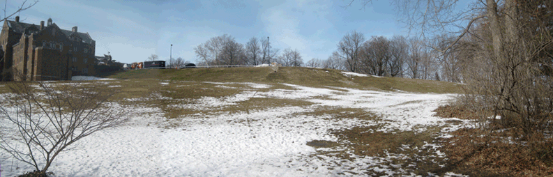
Additionally regarding the landscape design provided in the final document: Why is this berm so inconsistent? From a seemingly reasonable ~1.5" above the parking area it shields closest to Trevor Hall before growing to 5' above the drive as it continues at least 30' beyond the specified 70' down the drive from the parking area. It shows a slope as steep and high as that built to contain the large Eastern lot above, but consistently steeper and much longer and shoved out virtually to the limits of the slope and property line, covering both the gentle most walkable slope up this section of the grounds and terminating it's massive slope into a double row of pine trees cutting off a much traveled route around the grounds into a dead end intersection of barriers. And lastly, why would they even bother with the plantings atop this new massive slope? It appears that the black walnut at the end of Summit is to go as well?
Disclaimer: The lift vehicles being fired up and moved around the parking lot this morning shortly after 4:30a.m. may have affected my ability to think clearly